About Garmin Map 78S GPS
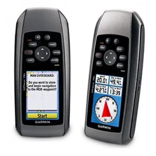
The Garmin Map 78S GPS is a top-rated, best-seller navigation device revered among outdoor and marine enthusiasts. This rarefied handheld unit boasts a redoubtable feature set: up to 2,000 waypoints, 200 routes, a blue-ribbon 3-axis compass, barometric altimeter, and a worldwide basemap. Designed to float on water and meet IPX7 waterproof standards, it excels in rugged environments. Garmins high-sensitivity GPS with HotFix ensures reliable accuracy (<10 meters), while wireless data sharing, custom map support, and a sunlight-readable display round out this hot deal for explorers and sailors alike.
Versatile Navigation & Competitive Edge
The Garmin Map 78S GPS offers a simple application method: Power on, mark waypoints, and navigate via its user-friendly interface. Suitable for use on boats, outdoor trails, or rugged terrain, it adheres to a broad range of application surfaces. Its competitive advantages include customizable maps, renowned geocaching compatibility, wireless data sharing, and floatable designmaking it indispensable for both recreational users and marine professionals seeking precise, uninterrupted navigation.
Payment, Dispatch, and Domestic Availability
We provide transparent quotations for the Garmin Map 78S GPS to ensure clarity before purchase. Packing & Dispatch is handled with stringent attention for safe delivery; secure packaging keeps the device protected during transportation. Orders are shipped across India, with the main domestic market focusing on outdoor professionals, marine suppliers, and adventure retailers. Trust our dependable packing, timely dispatch, and comprehensive service for your GPS procurement needs.
FAQs of Garmin Map 78S GPS:
Q: How does the Garmin Map 78S GPS enhance outdoor and marine navigation?
A: The devices high-sensitivity GPS with WAAS and HotFix ensures precise tracking, while features like the worldwide basemap, wireless data sharing, and floatability make it highly reliable for both land and water navigation.
Q: What surfaces and conditions is the Garmin Map 78S GPS suitable for?
A: Designed for versatility, it operates seamlessly on land, in boats, and during all weather conditions, due to its IPX7 waterproof and floatable build.
Q: Where can custom maps and BlueChart g2 be uploaded on this device?
A: You can upload Garmin custom maps and BlueChart g2 via the microSD card slot or through USB using compatible mapping software.
Q: How long does the battery last and what type does it use?
A: The Garmin Map 78S GPS is powered by 2 AA batteries (not included) and offers up to 20 hours of continuous usage, making it ideal for extended adventures.
Q: What is the process for acquiring, packing, and dispatching this GPS in India?
A: Upon placing a quotation, the product is securely packaged and dispatched promptly, with reliable transportation arranged for swift delivery across the main domestic market in India.
Q: What are the key benefits of using the Garmin Map 78S for geocaching and waypoint management?
A: It supports paperless geocaching, stores up to 2,000 waypoints, and allows easy waypoint marking for efficient adventure planning and navigation.




 Send Inquiry


 Send Inquiry